Penang Forum is gravely concerned about recent press reports of authoritative government agencies warning of signs of soil instability and more landslides within the area of the Oct 19 landslide at the construction site of the Paya Terubong paired road in Bukit Kukus, Penang.
In a press interview on Oct 21, the head of the Perlis, Kedah and Penang Department of Mineral and Geoscience, Azhari Ahmad, pointed out that his team on-site encountered a natural stream flowing downhill.
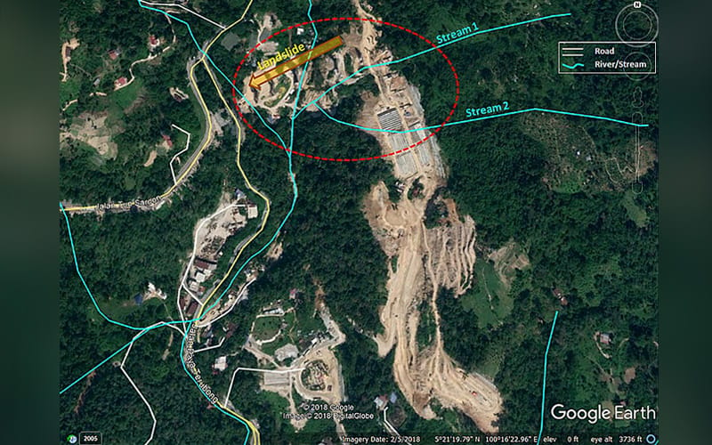
Our desktop investigation using geographic information system mapping of the river system in the vicinity of the area reveals that there are possibly two streams that flow westward down the slopes of Bukit Kukus, as shown in the map below.
The stream that Azhari’s team encountered is probably Stream 1 in the map. Only personnel authorised within the restricted zone of the construction area can ascertain if Stream 2 does indeed exist.
Azhari explained that “due to its (the stream’s) shallowness, when it rains, the water can become swift and overflow into the nearby area” – hence the fear that excess run-off from rain can further compromise the stability of the exposed slopes in the vicinity of the landslide that already occurred.
Azhari’s statement underscores the fact that innocent-looking small streams should not be dismissed as inconsequential in hillside development. We should not underestimate the forces they can unleash after a rainstorm.
The lesson from the collapse of the embanked road in Tanjung Bungah less than a year ago (see images below) seems to have been lost on our authorities.

Back to Bukit Kukus, the photo below depicts our observation of the landslide event upon closer examination of photos taken on Oct 19.

The bold red-dash line roughly outlines the extent of the landslide. The lower portions of the two pillars exposed by the landslide are covered with soil.
The magenta-dash lines roughly mark the two terraces and two slopes before the landslide occurred.
The remaining terraces and slopes are visible in the area marked with the yellow-dash line. There is still a risk that this area may collapse at or after the next heavy rainfall.
Azhari further said, “For now, we have managed to divert the water flow from the stream to elsewhere.” Mark the words “for now” – a temporary diversion done in a morning surely cannot be a long-term, even a middle-term, workaround for such an extensive area of steep slopes rendered completely barren.
We can only hope that the temporary diversion of the stream above this site can help somewhat in preventing further slope collapse while the search and rescue operations are ongoing.
Already, in his interview with TV1 late on Oct 21, Penang Fire and Rescue Department deputy director Mohamad Shoki Hamzah revealed there was some soil movement: “We found soil at the banks had moved apart and… collapsed.”
Let us pray that Mother Nature takes kindly to the valiant efforts of all on-site personnel to search for the missing and does not unleash another downpour to further destabilise the landslide area until after the search and rescue efforts are safely completed.
Penang Forum is an NGO that promotes such things as participatory local democracy and sustainable planning and development.
The views expressed are those of the author and do not necessarily reflect those of FMT.